Elevation Models
Geolocating a pixel in an overhead image requires knowing the terrain height at that point. Without elevation data, the sensor model must assume a flat surface — and the resulting horizontal error grows with both the off-nadir angle and the true terrain relief.
Ellipsoidal vs. Orthometric Height
Sensor models in this library work in ellipsoidal heights — meters above the WGS84 reference ellipsoid. Most DEM sources (including SRTM) store orthometric heights — meters above mean sea level (the geoid). The difference between these datums (the geoid undulation) varies from about -106 m to +85 m globally.
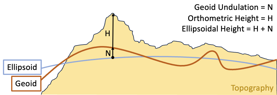
Always apply a geoid correction when using orthometric DEM data. Failing to do so introduces the full geoid undulation as an elevation error — which, at high off-nadir angles, can produce horizontal errors exceeding 50 meters.
Quick Start
The simplest useful configuration: SRTM terrain tiles, EGM96 geoid correction, and a sea-level fallback for locations without DEM coverage.
from aws.osml.io import IO
from aws.osml.metadata import load_sensor_model
from aws.osml.elevation import ElevationModelBuilder, StoredDEMTileFactory
from aws.osml.photogrammetry import ImageCoordinate, SRTMTileSet

# Build the elevation model
elevation_model = (
    ElevationModelBuilder()
    .add_source(
        StoredDEMTileFactory("/path/to/srtm_tiles"),
        SRTMTileSet(),
    )
    .add_fallback(0.0)
    .with_geoid("/path/to/egm96_15.tif")
    .build()
)

# Use with a sensor model for accurate geolocation
with IO.open("image.ntf", "r") as reader:
    sensor_model = load_sensor_model(reader)
    image = reader.get_asset("image:0")
    width, height = image.num_columns, image.num_rows

world = sensor_model.image_to_world(
    ImageCoordinate([width / 2, height / 2]),
    elevation_model=elevation_model,
)
The ElevationModel Interface
All elevation models implement two methods:
set_elevation(world_coordinate)— updates the elevation component of aGeodeticWorldCoordinatein place. ReturnsTrueif the elevation was set,Falseif the model has no data at that location.describe_region(world_coordinate)— returns anElevationRegionSummary(min/max elevation, no-data value, post spacing) for the area near the coordinate, orNone.
Using the Builder (Recommended)
ElevationModelBuilder composes these classes for you. It is the
recommended path for most use cases — it handles coordinate
normalization, multi-source priority ordering, and geoid correction
automatically.
Method |
Purpose |
|---|---|
|
Add a DEM source with optional spatial condition |
|
Add a pre-built |
|
Add a constant elevation as the lowest-priority source |
|
Apply geoid undulation correction globally |
|
Assemble the final model; |
Sources are tried in the order they are added. The first source that successfully provides an elevation value wins. Sources with a condition are skipped when the condition evaluates to False for the query point.
from aws.osml.elevation import (
    ElevationModelBuilder,
    ShapefileQuery,
    StoredDEMTileFactory,
)
from aws.osml.photogrammetry import SRTMTileSet, GenericDEMTileSet

local_coverage = ShapefileQuery("/path/to/local_coverage.shp")

elevation_model = (
    ElevationModelBuilder()
    # First priority: high-res local DEM (only where coverage exists)
    .add_source(
        StoredDEMTileFactory("/path/to/local_dem"),
        GenericDEMTileSet(format_spec="%ld%lh_%od%oh.tif"),
        condition=local_coverage,
    )
    # Second priority: global SRTM (no condition — used everywhere else)
    .add_source(
        StoredDEMTileFactory("/path/to/srtm_tiles"),
        SRTMTileSet(),
    )
    .add_fallback(0.0)
    .with_geoid("/path/to/egm96_15.tif")
    .build()
)
SRTMTileSet maps coordinates to USGS-style file names (e.g.,
n38_w078_1arc_v3.tif). GenericDEMTileSet supports other naming
conventions via a format string (the example above uses a
lat_lon.tif pattern; DTED Level 2 would be
"dted/%od%oh/%ld%lh.dt2").
Note
Shapefiles used with ShapefileQuery must be properly split at the
+/-180 degree longitude antimeridian. Standard datasets (Natural Earth,
GSHHS) are already split correctly.
Note
The .with_geoid() correction is applied globally to the final
elevation result. If you mix sources with different vertical datums,
compose OffsetElevationModel manually around only the orthometric
source and add it via .add_elevation_model().
Warning
EGM2008 at 1-arc-minute resolution requires approximately 1.8 GB of RAM. For most applications, the 5-arc-minute grid (~75 MB) provides sufficient accuracy. EGM96 at 15-arc-minute resolution requires only ~8 MB.
Composing Models Directly
The builder is convenient but not required. You can compose the elevation model classes directly for full control. The toolkit provides several implementations that compose together:
Class |
Description |
|---|---|
|
Reads DEM raster tiles and interpolates elevation values. Requires a |
|
Returns a fixed elevation for all coordinates. Useful as a lowest-priority fallback or for testing. |
|
Calls |
|
Gates an inner model behind an |
|
Wraps an inner model and adds a datum offset after elevation is set. Use with |
|
Normalizes longitude/latitude before delegating to an inner model. |
Conditions
GeometryCondition connects an ElevationModelCondition to a
GeometryQuery — it evaluates True when the query point falls
inside a geometry returned by the query. ShapefileQuery is the
built-in GeometryQuery implementation. Pass invert=True to match
points outside the geometry instead. For non-spatial conditions,
subclass ElevationModelCondition and implement is_true().
Example: Multi-Source with Shoreline Masking
High-res local DEM where coverage exists, global SRTM on land elsewhere, zero over water, with geoid correction applied globally:
from aws.osml.photogrammetry import (
    ConditionalElevationModel,
    ConstantElevationModel,
    DigitalElevationModel,
    MultiElevationModel,
    OffsetElevationModel,
    SRTMTileSet,
    GenericDEMTileSet,
)
from aws.osml.elevation import (
    GeometryCondition,
    RasterOffsetProvider,
    ShapefileQuery,
    StoredDEMTileFactory,
)

# Geometry condition: on land
land_condition = GeometryCondition(ShapefileQuery("/path/to/ne_10m_land.shp"))

# High-res local DEM (conditional on coverage area)
local_coverage = GeometryCondition(ShapefileQuery("/path/to/local_coverage.shp"))
local_dem = ConditionalElevationModel(
    inner_elevation_model=DigitalElevationModel(
        tile_set=GenericDEMTileSet(format_spec="%ld%lh_%od%oh.tif"),
        tile_factory=StoredDEMTileFactory("/path/to/local_dem"),
    ),
    em_condition=local_coverage,
)

# Global SRTM (conditional on land)
srtm_dem = ConditionalElevationModel(
    inner_elevation_model=DigitalElevationModel(
        tile_set=SRTMTileSet(),
        tile_factory=StoredDEMTileFactory("/path/to/srtm_tiles"),
    ),
    em_condition=land_condition,
)

# Compose: local → SRTM → sea level
terrain = MultiElevationModel([
    local_dem,
    srtm_dem,
    ConstantElevationModel(0.0),
])

# Apply geoid correction
elevation_model = OffsetElevationModel(
    inner_elevation_model=terrain,
    offset_provider=RasterOffsetProvider("/path/to/egm96_15.tif"),
)
Open-Source Elevation Data
Data |
Source |
Resolution |
Format |
|---|---|---|---|
SRTM |
1 or 3 arc-second |
GeoTIFF |
|
EGM96 geoid |
15 arc-minute |
GeoTIFF |
|
EGM2008 geoid |
5 or 1 arc-minute |
GeoTIFF |
|
Natural Earth land |
1:10m |
Shapefile |